I had planned to be in Springfield, Missouri tonight, but instead, I am over 200 miles east in a Days Inn I raced to while fleeing an oncoming thunderstorm. I'm not even sure what town I'm in.
I got a late start leaving Hopkinsville this morning because I took a long run and did some exploring. I went back to the Trail of Tears park, and I spent some time walking and reading the plaques. There's a cemetery in the park where 2 Cherokee chiefs are buried who died during the encampment there. Their names were Fly Smith and Whitepath. The plaques in the park state that Whitepath was a famous Cherokee war chief who disagreed with the passive position the Cherokee took during the years leading to the removal. There are statues of the chiefs. Whitepath's statue is shown standing looking skyward. He has both arms at his side, but one hand is open in a question, and the other hand is clenched in frustration. It's a very moving piece.

I left Hopkinsville at around 11:00. I avoided the interstates entirely today and paid a price in miles. I rolled through western Kentucky along back roads and watched acres and acres of harvested corn and grain fields race by me. The landscape along state route 80 west is punctuated by super sized grain storage sheds and tractor dealership.
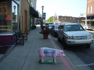
I stopped briefly in Cadiz to walk thru a couple of the antique shops and look at the Indian artifacts they had. I did not intend to stop, but as I was approaching the town center, I noticed many of the shops and public buildings along the road all had decorated hog statues placed out front. The statues were all the same size and appeared to be the same pig, but each was decorated in a unique theme chosen by the owner. When I reached the town center, I found the main street was lined with banners advertising the Trib County Ham Fest which takes place next weekend. I stopped to get a closer look at a few of the painted porkers and wandered in some of the shops.

When I left Cadiz, I raced toward a collection of state parks known as the Land Between the Lakes. As the name indicates, there are two large man made lakes near Cadiz that divide the area. Much to my dismay, I discovered the bridges that crossed those lakes were very high and very narrow. I was exceedingly uncomfortable navigating the bike over them. The fear factor rose considerably whenever an on coming semi would pass me on those bridges. Unfortunately I discovered later, the same long, high, thin bridge design was used to span the Mississippi and Ohio rivers too.

My next stop was another small town called Mayfield near the western border of Kentucky. Here, I found the small mom and pop restaurants I declared dead yesterday were still alive and thriving. I passed an ice cream stand that looked like it was in operation since 1950. It was located at the end of an airport runway and it did not have the name Dairy Queen, Brewsters, or Ben and Jerry’s anywhere on it. I also passed two or three small restaurants that had signs out front declaring their specialty was catfish. I chose to have lunch at a placed called Carr's Bar BQ Barn.
Carr's is on the main drag in the "historical" city layout portion of Mayfield. Almost every town in America that existed before strip malls and interstates has a city block that was designed for pedestrian window shopping. Most towns are rediscovering the value of these areas and renovating them. Mayfield is no exception. Many of the storefronts in the historical portion are empty, but they all look recently restored. Hopefully, they will be occupied soon.
Carr's is in a long narrow red building with empty lots on either side. A man I spoke to in the parking lot told me there once were large buildings on either side of Carr's which explains the long narrow design. He also said the place was called the Hole In The Wall then, and it had been in business for 50 years. I was attracted to Carr's because of the smell. On a bike, not only can you see more than from within a car, you can smell more too. This is not always a good thing, but in this case it was.
Inside, Carr's looks its age, and so did it's patrons. I'm guessing mostly long time regulars eat at Carr's because when I walked in every grey haired head seated at the lunch counter turned in unison to stare at me. I chose the open stool closest to the door. I quickly noticed that none of the other customers appeared to be younger than 60, and many of them were practicing the dieing art of eating and smoking at the same time.
Before I could change my mind and make a retreat, a woman behind the counter asked me what I would like. I asked for a menu, and with a shake of her head she told me she did not use them. I glanced around for a board or sign that listed what was available and found none.
I said, how do I know what you have? She said, we have the usual stuff. You know, she said, burgers and barbeque. Once upon a time this probably made perfect sense, but I have spent the last 25 years eating in places where every detail of food propriety has been carefully planned by corporate franchise menu specialists. I did not even know how to ask for something that did not appear on a laminated menu. She told me the pulled pork platter was good. She was right. I wolfed it down without even noticing the cigarette smoke wafting through the air. I'm fairly sure she made the price up on the spot too, but it was more than reasonable. If you're ever in Mayfield, stop at Carr's.

From there, I made a run for the Mississippi. I got lost twice which is very easy to do since some of the route numbers don't match what Google maps says, and some roads just end even though Google maps indicate otherwise.
While making my way to Wickliffe to view the Indian Mounds there, I was almost blown off the road by an on-rushing semi. The wind blast ripped my tank bag off the bike and hurled it into the road. Unfortunately, before I could retrieve it, a guy driving a big camper ran over it. I looked him in the eye just before he hit my bag, that I was vigorously gesturing for him to avoid, and I swear he was smiling; some people are just evil.
After I collected the remains of my bag and its contents, I made my way to the Indian Mound park only to find it closed. The day was going down hill fast.

I briefly stopped at a small park at the confluence of the Ohio and Mississippi rivers where Louis and Clark camped while learning how to determine latitude and longitude.

I had planned to go up to Cape Girardeau and visit a large Trail of Tears park located where the Cherokee crossed the Mississippi. It was already 3:30, however, and after finding the Indian Mound park closed I decided not to risk riding to another park without knowing for certain that it would be open.
As I continued my trek west toward Springfield, I noticed the sky darkening. There are many things to avoid on a motorcycle, but near the top of the list is a thunderstorm on a back road in Missouri with no shelter. I loitered about a truck stop for a while trying to decide if I should wait for the coming storm to pass or chance more time on the road.
I had not made hotel arrangements for the night. My plan was to price shop a few hotels in one of the small towns I rode through. Instead, I looked at the map and picked what I thought was a good terminus for today. I chose a place called Poplar Bluff. On the map, it looks to be about halfway from the Mississippi to Springfield. When I called the Comfort Inn there, the woman who answered informed me they were in the middle of a violent thunderstorm. I made another plan.
The people at the truck stop told me there were hotels 15 miles west so, after checking the sky a few more times, I nervously set out in search of a place to stay. I quickly regretted that decision when, almost immediately, I was forced to race a lightning spewing monster black cloud to my present location.

I’m done for the day.

2 comments:
Hi, I live in Hopkinsville, KY. Reading up to the present, I see you've already had some scary moments passing through LBL and other areas. Indeed, I hope you find a safe path to Oklahoma and when you return home to Georgia.
In case your interested, I found your blog because I have a Google alert searching for Hopkinsville references.
How ironic: Indian Mound Park closed in commemoration of Columbus Day!
Post a Comment